


olivieraron
User
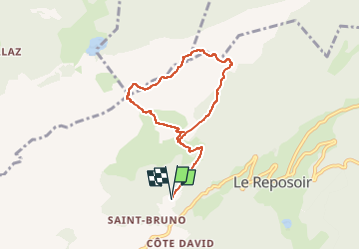

Length
7.2 km

Max alt
2092 m

Uphill gradient
751 m
Km-Effort
17.2 km

Min alt
1332 m

Downhill gradient
750 m
Boucle
Yes
Creation date :
2024-07-24 17:55:04.642
Updated on :
2024-07-24 17:58:02.266

FREE GPS app for hiking
 SityTrail
IGN / Geographical institutes
SityTrail Plus
The world is yours!
About
Trail of 7.2 km to be discovered at Auvergne-Rhône-Alpes, Upper Savoy, Le Reposoir. This trail is proposed by olivieraron.
Positioning
Country:
France
Region :
Auvergne-Rhône-Alpes
Department/Province :
Upper Savoy
Municipality :
Le Reposoir
Location:
Unknown
Start:(Dec)
Start:(UTM)
307809 ; 5098094 (32T) N.
Comments